Our next town, named for the Biblical land of Canaan, was auctioned at New London in 1738, bids starting at Ł60 per right, the high rate for Litchfield County. Settlers flocked in the same year, and a town was incorporated in 1739. The present Canaan, which does not include the village of that name, is made up of mountains on the south and east, with a plain along the Housatonic, from which cultivated valleys reach back into the hills. It contains portions of the Housatonic State Forest.
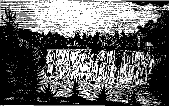
U.S. 7 crosses from Salisbury at Lime Rock Station, and continues north under the cliffs of Canaan Mt. At South Canaan there is an attractive Congregational Church, erected in 1802, with pedimented doorway and Palladian window; the tower is rather heavy for the building. R. 43 leads west to Falls Village, where the Hoosatonic Gorge shows fine specimens of folded limestone below the dam, with many characteristic limestone plants.
To our right, R. 43 runs southeast up the beautiful Hollenbeck Valley to Cornwall. About 1 1/2 miles from South Canaan, a road climbs south 1 mile to Music Mountain, where the Gordon MusicaI Foundation has established a summer school, and concerts are given weekly during the season. Farther east on R. 43 we pass the hamlet of Huntsville, seat of an early iron forge. One can cross at this point to the Undermountain Rd., along the south slope of Canaan Mt., with remarkable views of the mountains to the northwest. Steep Rd., worthy of its name, climbs north through an attractive ravine to a cultivated plateau, and past Wangum Lake to Norfolk. The abandoned Crissy Rd., which forks to the right about 1 mile before the Lake, may be followed to Norfolk on foot. About a mile northwest of Wangum Lake by an old wood road, is a Red Spruce Swamp, with trees 30 inches in diameter. On Canaan Mt. one should guard against rattlesnakes. From the Meekerstown Rd., which leaves the Undermountain Rd. farther east, a half mile climb leads west to Ojibway Tower, with a good horizon, on the site of an old Indian lookout.
The Appalachian Trail comes down from Cornwall through the Housatonic State Forest and *Deane's Ravine, a cascade brook of great beauty, reached by road 1 1/2 miles southeast from Lime Rock Sta., with a short walk up the stream. The Trail then climbs over rock ledges to Barrack Mt., with good views of the Housatonic Valley, and down to the crossing at Falls Village.