The town of Cornwall,. named for one of the counties of England, was auctioned off at Fairlield in 1738, and settlement began the same year, largely from eastern Connecticut. A town was not incorporated until 1740, and for some years there continued to be trouble from non-resident proprietorship. Cornwall consists of mountains and upland farms surrounding a small central valley, avoided by the first settlers because of its heavy stand of pine, which made land clearing difficult. The town is characterized by pine groves, stone walls and wide offlooks. During the 19th century, Cornwall was known for its schools, and iron was smelted at Cornwall Bridge and West Cornwall, utilizing local charcoal. There are considerable summer colonies. The town contains Mohawk Mt. State Park, Housatonic Meadows State Park (headquarters in the town of Sharon) and parts of Mohawk and Housatonic State Forests.
Coming from Kent along the Housatonic River, U.S. 7 crosses to the town of Sharon by a lofty concrete bridge with a line arch, beneath which one can see the old Covered Bridge, preserved as a landmark. Before reaching Cornwall Bridge, R. 45 comes down from Warren, with a splendid view of the Valley and the blue mountains. A little beyond this, a tramping trail leads off to the right up the beautiful Dark Entry Brook, well worth the climb, eventually reaching Mohawk Mt. There is a side trail to Colts Foot Cave.
At Cornwall Bridge we turn northeast on R. 4, along the hemlock-shaded Furnace Brook, reminiscent of the early iron works. Cornwall Village, just off the highway, has a white Colonial church, and the Calhoun Memorial Library and Town Hall of gray granite, given by John E. Calhoun in 1908. Rumsey Hall, a school for younger boys, was established in 1901. There has been a succession of schools on this site, beginning with Alger Institute in 1847. Still earlier, the Cornwall Mission School (1817-1827) was located here. It began with Henry Obookiah, a Hawaiian stowaway, and other youths from the Islands, who were to be trained as missionaries to their people. Later on, students were brought from various Indian tribes, including Elias Boudinot, son of a Cherokee chief who married a Cornwall girl, to the consternation of the neighborhood; their son achieved distinction as a colonel in the Civil War. Southeast of the village are the *Calhoun Pines of unusal (sic) height, sometimes called the Cathedral Pines. This is one of the finest stands in Connecticut, probably representing field pine rather than primeval forest, with an understory of hemlock and hardwood. They may he seen from the roads below the slope, or by the blue-marked trail that climbs through the Pines toward Mohawk Mt.

Route 43 leads north from R. 4 through Cornwall Hollow, where we pass the Sedgwick Monument, with a Mexican War cannon, erected in honor of Major General John Sedgwick, killed in 1864, whose home was in this neighborhood. The highway follows the valley to Canaan. Route 128 passes through *Cornwall Center, with one of the finest views in the State. It is here we begin to appreciate Cornwall Village. Barber in 1836 described 'the church and the little cluster of white painted buildings surrounding it, at the bottom of a deep valley," and "the mountains and lofty hills which rise immediately on almost every side." R. 128 continues to West Cornwall, where there is another old Covered Bridge. About a mile short of this, by climbing to the south a short distance, we find another notable stand of field pine, known as the Gold Pines. There are good northwest views from the slopes of Green Mt., south of the highway.
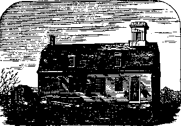
A State aid road which turns north from R. 128 takes us along an attractive brook and up to Cream Hill, with rewarding outlooks particularly from the northern slopes. Cream Hill Agricultural School, one of the first in the U. S., was established in 1845 by Dr. Samuel Gold and his son T. S. Gold, and continued until 1869. Theodore S. Gold (1818-1906) became the father of modern agriculture in Connecticut, starting the Agricultural College at Storrs, the Experiment Station, the State Board of Agriculture, for which he served as secretary, and editing the New England Homestead. The school building with its long south porch is still standing; the first or east unit of the present house was built in 1775 and is practically unchanged. An earlier house, the oldest in Cornwall, was built by James Douglas in 1750, and stands a few hundred yards to the north. The sash and shingle covering are new, but the porch is original, and the old sash and red clapboards can be seen in the west gable. A mile east from Cream Hill Rd. is the * North Cornwall Church of 1826, with pilasters on the front pediment and an octagonal belfry below the spire. There is good woodwork on the interior.
The Appalachian Trail of the Conn. Forest and Park Assn. comes from Kent Falls to Mohawk Pond, and climbs Mohawk Mt. to take in the views from the Fire Tower and the Pinnacle. The feeder trails from Calhoun Pines and Dark Entry Brook come in here from the west. The Appalachian Trail, which is part of the through tramping route from Georgia to Maine, then works north. Along the east slope of Yelping Hill there are fine views of the Hollenbeck Valley and the mountains to the northwest, and we can continue west through Housatonic State Forest.