Goshen, the next town to the south best reached from Norfolk by way of Torrington, was auctioned at New Haven in 1737, bids starting at the high mark of L60 per right.. The land was considered desirable, and the settlers who arrived in 1739 were largely the original purchasers. They came for the most part from New Haven, Wethersfield and Farmington. Town privileges were granted the same year. The name of the town was taken from the Biblical land of Goshen. It is a high hill country, most of it well above 1000 feet elevation.
Goshen was famous as a grazing country. In 1792, Alexander Norton bought local cheese to sell in the South, whither he had been ordered for his health. He continued in the business, packing first in hogheads and later in round boxes which held two cheeses. His second cousin, Lewis M. Norton, invented the pineapple cheese, securing a patent for the form in 1810; he made cheese from his own herd of 50 cows until 1844, when he began buying milk from other farmers and established what is believed to be the first cheese factory in the country. Before the middle of the century, Litchfield County was making nearly 3 million pounds of cheese a year. From Connecticut the industry spread to the West, especially Wisconsin. "The Connecticut Yankee brought a cheese hoop with him and wherever he went he made cheese."
R. 49 crosses a corner of Goshen, along the attractive Hall Meadow Brook. The first road to the right leads in 1/2 mile to a Rock House, or Indian cave (a short distance north of the road.)
While the traveler ordinarily will prefer to go to Goshen by way of Torrington, East Street, which runs from South Norfolk through North Goshen makes a scenic drive. The first house on the west side was the birthplace of Asaph Hall (1829-1907) the distinguished astronomer, who discovered the satellites of Mars. About 3/4 mile northwest of North Goshen is Tipping Rock, a glacial boulder weighing 80 tons which can be slowly moved back and forth. It lies about 100 yards north of a small reservoir. About a mile before reaching R. 4, a rough road runs east from East St. to Whist Pond. Much of this section of Goshen is controlled by the Torrington Water Board.
On East St., just north of R. 4 from Torrington, we pass the fine brick mansion on the hill, built by *Birdseye Norton between 1804 and 1810. There are 4 chimneys in the main house, heavy marble caps over the windows, with a Palladian window in the gable, and the wing has a porch with slender 2-story columns. As we go west toward the village, we see on the right a contrasting type, a Salt-box built in 1760, the oldest house in town.

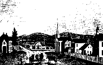
Goshen Village, built along a main street, is on a commanding site, and the white Church is a landmark for many miles. The old Academy, known as Eagle Hall, the third building south of the church, is now used for the Public Library. Still farther south is the handsome stone house built by Myron Norton in 1840, with 2-story columns. West of the village, a side road turns south to the attractive Dog Pond, where there are summer camps for boys. In West Goshen is an interesting hipped-roof house, built in 1777, of alternate dark and light brick; there is another of the same type in the southern part of the town. Continuing west on R. 4. we have fine views over Tyler Pond to the distant hills, and again toward Mohawk Mt.

Going north from Goshen village on R. 61, (two sources list it as 61, not sure the date it was changed to Rt. 63) in 1/2 mile a side road, not passable for cars, leads northeast to the foot of Ivy Mountain, 1642 feet elevation, standing out above the surrounding plateau. (Reached by auto on a road 2 1/2 miles farther north, or from East st.) On a clear day it is possible to see the Catskills on the west, the Bolton mountains beyond the Connecticut on the east, and the Meriden hills to the southeast. The summit is now a State Park, and famed for its low-bush blueberries. In another half mile, R. 61 passes on the left a Balsam Fir Swamp, practically the only area in the State where this tree is abundant and of fairly good growth. The highway is improved for only part of the distance to the north, but is worth taking for its views, especially the panorama before the descent to Cornwall Hollow.
From the village, R. 61 leads south to Litchfield along the 1200-foot ridge, with fine views, particularly toward the east.