New Milford, where we cross from Fairfield to Litchfield County, was a swarm sent out by the parent hive of Milford. A land company was organized at Milford, which bought from the Indians and sold rights to take up land. The first white settlement began in 1707, when John Noble arrived from Westfield, Mass., with his 8-year old daughter Sarah. New Milforrd was granted town privileges in 1712. Roger Sherman lived here during his early manhood. The town consists of a beautiful hill country, and on the west the Housatonic has cut a deep valley through the limestone. Lime making is an important industry, and tobacco is grown in the river valley.
Entering the town from the south, U. S. 7, which here follows Still River, makes an attractive drive. The first road to the west after crossing the line is worth taking for the view of Candlewood Lake. The village of New Milford, an industrial and trading center, was built up by the Housatonic R. R. and the cigar making which flourished after the Civil War. Present industries consist of tobacco packing, hatters' fur, and a bleachery and dye works.
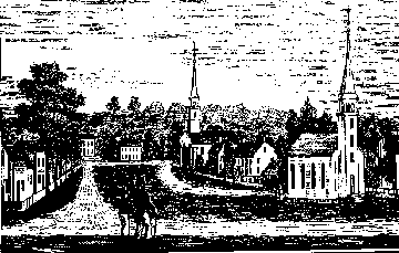
The older section of the village is built along a narrow Green. Starting at the lower end, where R. 25 comes in, we pass on the right the Canfield House, built in 1793. A little above this is the Town Hall, with a bronze tablet marking this as the Roger Sherman home site. Sherman, who later was to become famous as co-author of the Declaration of Independence and our other great national documents, came to New Milford in 1743, where he worked as shoemaker, county surveyor, merchant and lawyer, until he removed to New Haven in 1761. The Public Library stands at the end of the next block. Continuing north, we pass the Congregational Church, built in 1833, with its fine Greek Revival portico and "Christopber Wren" spire. The W. Taylor House of 1784, at the end of the street, was built on good Colonial lines. Facing the Green at the north end is the Lincoln Bust by Paul Morris, the gift of the late Edward Marsh. Canterbury School, a Roman Catholic preparatory school for boys, established in 1915, will be found a block above this on Aspetuck Ave. An earlier school of note was the Adelphic Institute. On the west side of the upper Green, the second building as we go south is the New Milford Historical Society, with portraits by Ralph Earle and other interesting exhibits, (open Mon., Tues., Fri., and Sat., 2:30-5:00.) Below this is the Senator Boardman House, another fine Colonial mansion, built about 1793.
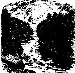
South from the village are two beautiful drives: R. 25 to Bridgewater, with its magnificent views of the Housatonic valley; and R. 133 following the river. On the latter, about 2 1/2 miles below New Milford, we come to the Housatonic Gorge, where the river leaves the limestone and cuts through the Quartz, mica and homblande of the Hartland Schist formation. The falls near the bridge are known as the "Great Falls" and the "Eel Rocks"; formerly lampreys and shad were caught here in large numbers. This was a favorite camping and fishing ground for the Indians, long after the white settlement. Chief Waramaug is said to have been buried nearby. The early proprietors organized the Cove Fishing Co., which lasted until the building of the great dam at Derby in 1877. At the lower end of the Gorge, about 1/4 mile up the rise at the left of the bridge, is *Lovers Leap, where tradition has it that Chief Waramaug's only daughter Lilinoah and her white lover plunged to a watery grave. The best view of this wonderful spot is from a particular point on the south of the highway, for which one must watch closely. The cliff faces the beautiful Cove, and Goodyear's Island, named from an early Indian trader, with its fine view down the river. There are picnic grounds in the center of the ledge, and others on the opposite side of the Gorge, where we find Indian Spring.
Above New Milford, U. S. 7 follows the Housatonic River and makes a scenic drive. About 1 1/2 miles from the bridge, after passing the old Isaac Hine House on the left, we come to the power house and pipelines of thee Conn. Light and Power Co.'s Rocky River plant. During slack hours, water is pumped from the river into the immense storage reservoir on top of the hill created by Candlewood Lake, and run down again as required. About 1/3 mile beyond this point a foot trail leads west to Candlewood Mt. The path climbs to Candlewood Cave, with a good easterly view, continues to another viewpoint on the northwest of the mountain, and then drops down to R. 37, just above the highway junction. Across the river from the main highway we see the extensive Limestone Quarries at Boardman's Bridge. Route 37 to Sherman makes a good drive, which we shall follow later. On the left of U. S. 7, about 2 1/2 miles beyond R. 37, is Tory's Hole, a large natural cave in the limestone, with its appropriate Revolutionary legend. There is another cave in the ledge along the highway at Strait's Rocks. On the right, just before reaching Gaylordsville, is the George Washington Oak, with a marker, where Washington and Lafayette rested, on the road which forded the river at this point. After crossing the Housatonic, Long Mountain, lying to the east, gives fine views of the river. One shoulder is crossed by a rough country road, and it pays to walk south along the ridge from that point.
North from New Milford, R. 129, improved for part of the distance, leads in about 5 miles to the Mica Quarry, northwest of Merryall and south of Peet Hill. The quarry has been abandoned, but interesting minerals are still to be found in the dumps. It has produced some very fine cut aquamarines and helidor, a small amount of gem garnet, and good specimens of beryl, tourmaline garnet, columbite and uraninite. Bear Hill, about a mile northeast of Merryall, is worth climbing for its views to the west and south.