THE HISTORY OF MOLLY FISHER ROCK
Photos by Carol A. Hanny

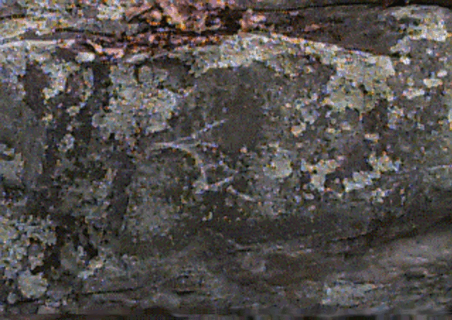
Molly Fisher Rock is situated above the Housatonic River in Kent, Connecticut. The boulder has inscriptions that have never been deciphered. If you know of any similar inscriptions, or just want to add your ideas, please e-mail me at channy@skyweb.net
© Carol A. Hanny 2000
MY thoughts:
-I view the inscription on Molly Fisher as a historic map for migrating indians. After the Pequot War of 1637 (to approximately 1675), most tribes moved out of the area. Many tribes moved across the state, joined tribes in the western half of the state, and moved north up the Housatonic to join the tribes at Stockbridge, Massachusetts. (Mission House). Then, as the whites encroached on their land, the indians moved west to the Great Lakes area, and farther west.
-I have read that Native Americans, when traveling long distances, stayed on the ridges, keeping out of the swampy valleys. This would enable them to hunt along the way.
-I believe Molly Fisher Rock is a map of the immediate area, approximately from the Great Falls in the north and maybe Kent or New Milford in the south. The curved lines I view as the Great Falls, a major landmark and fishing area. The lines would be trails on the hill tops.
-I think the lines were made with a metal tool, again showing that it is historic, not prehistoric.
NOTES FROM VARIOUS SOURCES ABOUT MOLLY FISHER ROCK
These are direct quotes from the source specified, or a paraphrase of the material.
FROM THE ANNUAL REPORT OF THE BUREAU OF ETHNOLOGY
J. W. Powell, director, 1888-89, page 75-76, Connecticut section
-The following account is extracted from Rafn's Antiquitates Americanae (a):
-In the year, 1789 Doctor Ezra Stiles, D. D., (president of Yale University) visited a rock situated in the Township of Kent in the State of Connecticut, at a place called Scaticook, by the Indians. He thus describes it: Over against Scaticook and about one hundred rods East of the Housatonic River, is an eminence or elevation which is called Cobble Hill. On the top of this stands the rock charged with antique unknown characters. This rock is by itself and not a portion of the Mountains; it is of White Flint; ranges North and South; is from twelve to fourteen feet long; and from eight to ten wide at base and top; and of an uneven surface. On the top I did not perceive any characters; but the sides all around are irregularly charged with unknown characters, made not indeed with the incision of a chisel, yet most certainly with an iron tool, and that by pecks or picking, after the manner of Dighton Rock. The Lacunae or excavations are from a quarter to an inch wide; and from one tenth to two tenths of an inch deep. The engraving did not appear to be recent or new, but very old.
NOTES FROM THE HISTORY OF KENT- 1897 - ATWATER
-p. 73 - Scatacooks, wanderers who retreated before the advancing colonists of CT
-founder = Pequot - Gideon Mauwehu, lived one time in or near Derby, moved then to Newtown, then to New Milford
-1729- Scatacooks were owners (of the Kent area) from New Fairfield (Sherman)
-moved to Dover, during a hunting expedition, came to the summit of a mountain in Kent which rises west of the Housatonic, settled (no white men), invited old friends
-whites came in 1738
-1742 - Moravian Missionaries
-Shekomeko = Indian village between CT and the Hudson
-missionary in Sharon
-Moravians were eminently successful
-p. 77- 1767 - the remainder became anxious to remove to Stockbridge, invited to come (sold land, some stayed)
FROM THE HOUSATONIC, PURITAN RIVER BY SMITH
-p. 38 - all the tribes represented fairly recent emigrations from a common center, traditionally Scatacook in Kent
-p. 36 - they were driven out of the Hudson Valley
-p. 40-41 - In conformance with the Indians' own legends, it is generally agreed by local historians that they first entered the Lower Valley from the west at Scatacook in southern Kent, about a mile below the original Potatuck, or Falls Place at Bull's Bridge. The Indian name was Pishgach-tig-ok, the Divided-broad-river-place, the place where a tributary comes into the broad river, specifically the place where the modern Ten Mile enters the main stream. It is one of the richest spots in the valley for Indian relics. There is dramatic value in the supposition that the Indians first entered the valley here through the break in the mountains that let in the Ten Mile from New York State for it was to the general reservation, set aside here by the Colony of Connecticut in 1752, that all the Indians of the Lower Valley gradually contracted, and it is certain that at this point their culture is at this moment coming to an end.
FROM THE CLIFFORD SPOONER ARTICLE ON MOLLY FISHER ROCK- 1930
- only rock with quartz running though it, fire scars, fireplace, charcoal burners cabin, inscription - southeast side of the rock, rock with same characters on southeast side in Saybrook CT, Molly Fisher used to visit it and say Captain Kidd buried gold near it.
FROM LITCHFIELD COUNTY HISTORY
- Kent - home of the Schaghticoke tribe, they having removed from the town of Dover, NY; Gideon Mowehn, the King of sachem of the Schaghticoke tribe, was a Pequot Indian, and in one of his hunting expeditions came to the summit of the mountain which rises almost preciptiously west of Schaghticoke, and, beholding the beautiful valley and river below, determined to make it the place of his future residence. (description left out) At this place Mauwehn collected the Indians and became their sachem and here the Moravians had a flourishing mission.
-Trumbull quote = "Mowehn, a sachem, who a few years before had removed with his Indians from Newtown to New Milford about the year 1728 ..... invited indians at New Milford, Oblong and others to settle; he could muster 100 warriors; whole number probably 500-600; 1839 - not more than forty; Pequot War ended 1637
FROM CONNECTICUT HISTORY BY TRUMBULL
-Mowehn, a sachem, who a few years before had removed with his Indians from Newtown to New Milford about the year 1728, invited indians at New Milford, the Oblong of New York and others to settle
-he could muster 100 warriors
-whole number probably 500-600
-by1839, there were not more than forty indians
-the Pequot War ended 1637
FROM THE ROCKS BEGIN TO SPEAK
- picture writing was used to leave information by hunting and traveling parties
- Denig ,tribes of the upper Missouri, He states that while warriors are off on the warpath, the main camp will move and, due to rain or snow, their trail may become obliterated. In such instances the Indians, leave intelligence in pictorial devices in some of their encampments as guides to the returning absentees. There is, however, this danger in these records, that if they are stumbled upon by their enemies in their war excursions they are as certain a guide to them as to their own people, and this is one of the reasons why it is seldom done. All warriors read and understand the devices of their enemies.
FROM THE INDIANS OF HOUSATONIC AND NAUGATUCK VALLEYS - ORCUTT 1882
-p. 64 - ....and then removed with most of the Derby Indians to Scatacook, in Kent....
A REFERENCE AT THE CONNECTICUT HISTORICAL SOCIETY
-Schagiticokes were Pequots, came to mine silver, traveled on a roadway from Kent to Stockbridge
FROM THE CONNECTICUT AMERICAN GUIDE SERIES - 1938
-p. 454 - Schaghticokes - during Revolution - acted as a liaison unit, relaying messages from Stockbridge to Long Island Sound by means of drumbeats and signal fires on Pickett Rock, Straits Mountain and Candlewood Mt.
Inscription on opposite side of rock from main inscription (picture 1).

Inscribed lines on top of Molly Fisher Rock.
SOME QUESTIONS AND CONSIDERATIONS. PLEASE FEEL FREE TO COMMENT ON ANY OF THESE.
1. Can the inscriptions be translated?
2. Is it a map of the area?
3. Does anyone know through what towns or areas the Pequots passed as they joined the Stockbridge Indians?
4. Does anyone know of other inscriptions in Connecticut or western Massachusetts?
5. What side of the river would they have traveled on?
6. What mountain passes might the Mohawks use? Other sources state that they followed river valleys.
7. There is supposedly a similar inscription in Saybrook, does anyone know about this?
8. Why would inscriptions be up on the mountain above the river?
9. Think about rock incorporation. Include natural markings of the rock in the interpretation.
10. In my research, I have read that most rocks and inscriptions are in out of way places. Do others find this to be true?
11. I know this is not Ogam, but could it be something similar?
12. I read there is an Ogam inscription in Hampton, CT. Any information on this?
13. The large rocks in the immediate area have fire scars on top? Signal fire area for Mohawk invasion?
14. Were the inscriptions made by historic Indian? They appear to be chiseled in using a sharp metal edge.
15. Was this a ceremonial area? Often ceremonial areas were in out of the way places, on tops of mountains, etc.
16. Is it on the east side of the river because the western side has steep areas, St. Johns Ledges, etc.?
17. Is it a map for the indians as they were traveling towards Stockbridge?
18. Nearby there is a stone chimney. Could this be the work of a bored charcoal burner?
19. There is lots of spauled quartzite in the area.
20. I read in Orcutt's History of Connecticut that Indians came to Kent to mine silver. Any other information on this?
21. Could this be an indian message to the stragglers from the Pequot tribe, coming to the Kent reservation or passing through to Shekomeko or Stockbridge?
22. There is some evidence of digging around the area. Is this from the 1976 Lenik survey?
Please feel free to e-mail with any thoughts, interpretations or information you might have. Thank you!
Back to my home page.