Amateur Archaeologist Walter L. Elliot of Quincy, Massachusetts, walked along Popham Beach, Maine, with a purpose. For years there had circulated rumors about Viking runic stones at Popham, persistently, with good cause. North in Nova Scotia and south in Bourne, Massachusetts, archaeologists unearthed runestones. Inland, stones turned up at Kensington, Minnesota, and at Heavener and Potteau, both in Oklahoma and near Arkansas.
Mr. Elliot found the Maine runestones. They looked like strudels with green patina.
Chiselled inscriptions were definitely Icelandic. Still, he had to give them a sight test for antiquity. Runestones in America would have been cut between the eleventh and fourteenth centuries, during which time lichens with a vast apathy would grow slowly. There lichens were, camouflaging a hail of Scandinavian words.
He took these stones home, accompanied by an outraged cry from the State of Maine.
Maine has a reputation of pulling archaeology out of Sunday supplement romances into science. The University of Maine excavation at Passadumkeag, along with several smaller digs scattered through the state, resulted in a detailed picture of Red Paint Man, inhabiting Maine about 1,000 B.C. His tools, utensils, and other Old Stone Age handicraft along with his usage of red ochre strongly suggest that this proto-Indian still practised Cro-Magnon culture. Another excavation at Pemaquid Point awoke a successful settlement from its long sleep under several feet of soil. Radiocarbon dating set it as early as 1540 A.D., and the colony persisted until it entered history and misgovernment with the coming of the Pilgrims and Puritans.
For years, archaeologists had been combing Maine for Viking artifacts. Until Walter Elliot's discovery, evidence had been circumstantial.
A German archaeologist pointed out that the Wawenock Indians who lived at Pemaquid Point used Icelandic numerals, and that when Bartholomew Gosnold sailed up the Maine coast, he saw Tarratine Indian canoes with leather square sails, definitely not an Indian innovation. Tarrantine territory included Popham Beach.
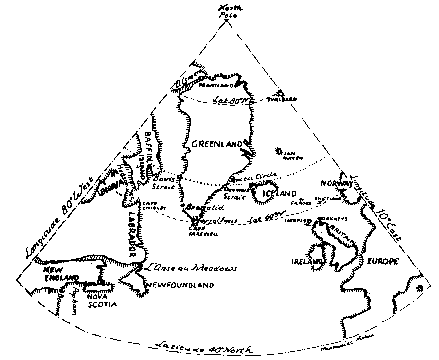
Besides Nova Scotia and Bourne runestones, archaeologists discovered a rusted medieval battle axe that some blonde Early Fu Manchu had dropped at Rocky Point, Massachusetts. Farther north, Norwegian Dr. Helge Ingstat excavated a genuine Icelandic colony, radiocarbon dated at 1,000 A.D., at L'Anse Au Meadow, Newfoundland. Laval University scientists dug out traces of a Viking longhouse at Ungava, just south of Hudson Strait.
The State of Maine asked Walter L. Elliot to return the runestones. When he refused, they took the matter to court. Elliot's answer was to hide them, claiming he had buried them where he found them. He challenged Maine to rediscover them.
Runestones are simply rocks with inscribed Norse runes. Viking scribes left them as written monuments to the fact that they had been there.
The Kensington Stone was the first publicized, accompanied by academic vituperative eloquence. Hjalmar Holand nevertheless broke the code and the story thus revealed matched facts in the medieval Norwegian court records. It was the story of Paul Knutson's search for Vikings in America A.D. 1355-1362.
The two Oklahoma runestones discovered at Heavener and Poteau, a few miles apart, have not yet been satisfactorily translated. Unlike hieroglyphics which a freshman archaeologist can decipher, the Viking text has the handicap of twelve different runic alphabets. Once the key alphabet is found, the translator has to wade through medieval language. Scandinavian forms, Germanic, and early and middle Anglo-Saxon grammar. Spoken and written runic languages were so different that literal translation is impossible. Then, each rune is not a letter; like shorthand, it is a symbol for a complete word. Some runes run right to left like Hebrew and Arabic, though the majority read left to right. Runestones are the keys to Vikings in America.
The Viking ship of exploration was not the longship and its derivatives; the cruiser skeid, the destroyer snekkja, and the ironclad ram jarnbardi, 1,000 years before the Monitor and Merrimack. These vessels were too narrow and had little freeboard. No ship could induce seasickness as expertly as these Viking warships.
The Norse merchant ship, the knarr, had lines as sweet as the longship, but she was beamy with high freeboard. Her hull was alive; it yielded before battering waves that could break a stiff ship. She was the most seaworthy craft ever built.
Norse navigation was surprisingly modern. An early Icelander, Star-Oddi, compiled sun postions for dawn and midday through the year. Skippers carried a hausanotra, an astrolabe to measure height angle of the sun. In place of a magnetic compass that in the Northland acts as though it had a fifty too many, Norse navigators used polarized light like the modern jetliner that travels faster than a political rumor. Their compasses were discs of the mineral cordierite. They held them before their eyes and, while turning slowly to scan the sky, they rotated cordierite. When the transparent mineral became opaque, they had direction, at right angles to the sun. The northern horizon is strongly polarized.
Contrary to the statements of the sagas and academic history, Leif Eriksson did not discover North America. A Norse merchant skipper was there first, probably off the coast of Maine.
Having completed trading in Norway, Bjarni Herjolfsson loaded his knarr with goods. He sailed toward his father's Icelandic homestead. He found his family gone with Eric the Red to Greenland, but they had behind a letter with sailing directions, including latitude, and length of sailing days - about 150 mile per day - give relative longitude.
Bjarni put out, toward Cape Farewell, Greenland, in August, the North Atlantic's most treacherous month.
Hardly had Iceland disappeared below the horizon when a screeching northeaster struck Bjarni's knarr with sledgehammer blows. It heaped and hounded the little ship. Its winds spun whipping waves that crashed with boiling foam. Spume blanketed the surface, reducing visibility to zero.
Where the northeaster struck Bjarni's knarr, it was smack on the storm's co-worker, the East Greenland Current flowing out of Denmark Strait in a southwesterly course at the rate of one knot.
Drifting southwestward, Bjarni entered an opaque region where the frigid East Greenland Current meets the warm Imringer Current out of the North Atlantic Drift. The result is Planet Earth's foggiest blot that blankets the Grand Banks for 200 miles.
After days upon days, the knarr broke out of fog, out of storm. Bjarni took sun sights and found himself more than 800 miles south of the Herjolfness latitude. Of relative longitude, he had no idea.
Then they saw land. It was forested and it was beautiful to look at. It was the North American continent.
Bjarni's sea-weary crew wanted to land. No men had been so exasperated with water since Noah got tired of it and landed at Mt. Ararat. Bjarni was a canny seaman, however. Here was unknown Yankee land, toward the end of August, a long, long way from Herjolfness where trade goods would bring handsome profits. After August, the North Atlantic equinoctial storms might isolate him until spring. Therefore he sailed along the coast, noting latitude. Then he turned northeast.
A few days later he made a second landfall. This time he saw spruce woods crowding the coast. The air was tangy, bracing, pungent, and again his crew wanted to land. He refused, and after noting latitude he continued out to sea, cruising north, then northeast.
His third landfall was Labrador, along whose coast he hugged until he reached the Cape Farewell latitude - about 60 degrees north - roughly that of Oslo, Stockholm, and Leningrad. He turned east and in a few days moored at this father's Herjolfness anchorage.
Bjarni Herjolfsson reached the North American continent - very likely the Maine coast - in A.D. 986 and went back to tell about it at the court of Earl Eric. One of the listeners among the nobility and their retinue of wild bores, phlegmatic wowsers, and other goofs happy under the wrath of grapes, was an impressionable fifteen-year-old boy, Leif Eriksson. Some years later, Leif obtained sailing directions from Bjarni and bought his knarr. Leif reversed Bjarni's epic voyage and anchored off Vinland in A.D. 1003, bringing with him well-paid skalds - poets - who exhausted the Icelandic national treasury of superlatives to make his name important.
Norse colonies followed. Sagas mention only two serious attempts, but sagas are stories of Icelandic nobility whose skalds were much addicted to rhetoric. There is hard evidence that Norse commoners settled in North America.
Those Greenland and Iceland colonies needed wood. None grew in these islands. Driftwood was never enough to satisfy demand. New England and the Canadian Atlantic provinces were heavily forested to the sea's edge. Besides, Maine, New Hampshire, Massachusetts, and perhaps Rhode Island, too, were attractive and promising where Greenland and Iceland were as inviting as cold spaghetti.
Even if sagas do not mention colonies of Icelandic commoners in the Western Hemisphere, the Vatican has documentary records. In its Icelandic Annals for A.D. 1121, it has an entry: "Bishop Eric sought Vinland."
Vatican records identify him as Bishop Eric Gnupsson. Icelandic sources tell more about him; in 1112, he was called before Pope Paschal II and appointed to the Greenland-Vinland bishopric.
Bishop Eric would not have wasted time in Vinland if there had been only one or two settlements. There must have been quite a number of Viking colonies built by Norwegians too busy with living to engage in the art and business of lying for posterity. They left behind runestones at Popham Beach, Maine Mohegan and Martinicus Islands, and Bourne, Massachusetts. And a rusty though perectly good battle axw at Rocky Point, Cape Ann.
Wawenock Indians of Pemaquid, Maine, used Icelandic numerals; no other Indian tribe except the Mayans had any mathematics. Bartholomew Gosnold's Tarratine Indians used leather square sails in their canoes. These could be raised and lowered, Viking fashion, and that gave Gosnold's crew a nice case of insomnia.
Finally Giovanni Verrazano, who discovered the Hudson River decades before Henry Hudson, anchored off Maine. He remarked in his memoirs that New England Indians were fair in coloring and almost Europeanized. Dressed in European fashions, they could pass for Welshmen, Spaniards, and Italians. Thus the Viking in New England saga can be reconstructed.
Despite the bloody misadventures of Leif Eriksson's relatives who tried to exploit his "discovery," Norse commoners, known for deeds, not bombast, settled in the New World including New England. Evidently they prospered, since more than a hundred years after Leif's voyage, the Vatican recognized them.
Climate and nature worked against them as they worked against the Greenland colonies. According to Dr. Otto Pettersen, the North Atlantic has an 800-year cycle between a climatic optimum of mild and pleasant weather and an inconveniently icy, stormy one. The Age of Viking Discovery and colonization happened during an optimum. When climate became less obliging, it isolated Greenland.
It also isolated Viking New England. The more numerous Indians absorbed the surviving Norwegians, which accounts for Giovanni Verrazzano's observations.
During the brief Anglo-French peace of mutual cheating between fighting, Samuel de Champlain sought Norumbega in Mt. Desrt Island, up to the Penobscot and the Kennebec Rivers. He was hundreds of years too late.